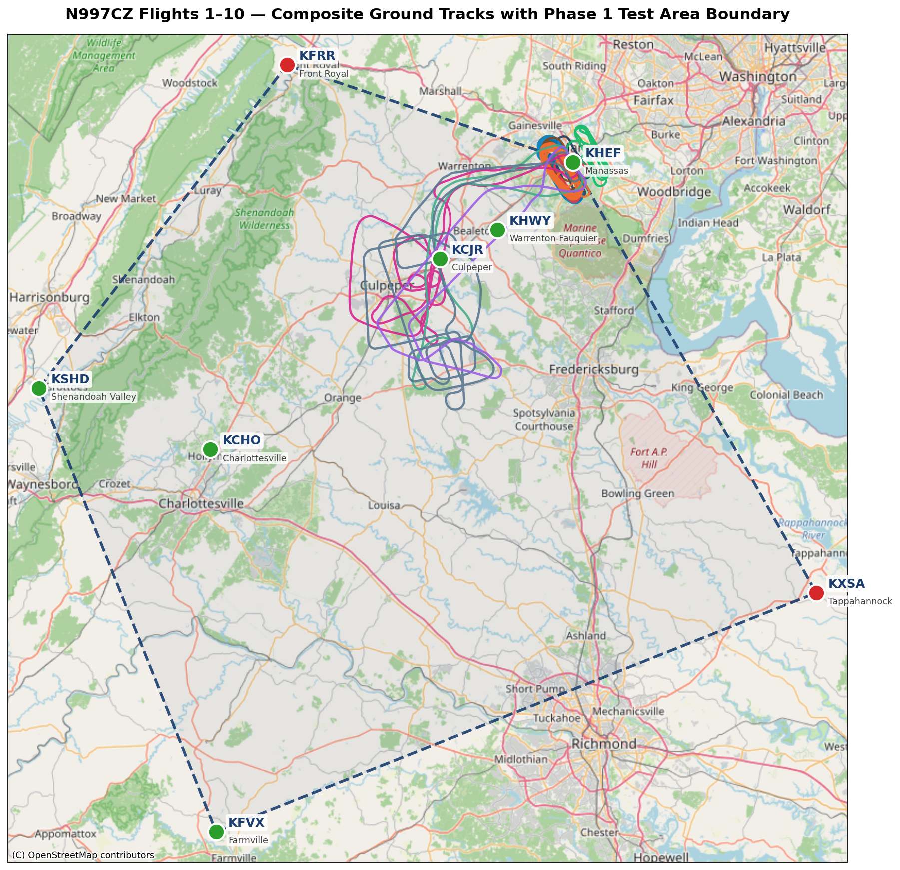
Every experimental amateur-built airplane has to do its first few dozen hours of flying inside a defined geographic test area. That’s a Phase 1 requirement, written into the aircraft’s operating limitations and signed off by the FAA’s Designated Airworthiness Representative (DAR) when the airplane is issued its airworthiness certificate. You can fly anywhere you want inside the area; you can’t fly outside it until Phase 1 is complete.
I went into the conversation with my DAR with an ambitious proposal: twelve airports scattered across central Virginia, several of them anchoring the boundary of the test area and all of them on the approved landing list — places I could put the airplane down on a runway if anything went wrong. The DAR took a look and came back with a constraint from the FAA: the approved landing list had to be reduced to no more than six airports. Twelve was too many; six was the cap.
So we kept the boundary pentagon and pared the landing list down. Two of those concepts are now separate:
The boundary — the pentagon that encloses the test area — is defined by five waypoints:
- KFRR — Front Royal-Warren County (NW corner)
- KHEF — Manassas Regional (NE corner, my home base)
- KXSA — Tappahannock-Essex County (SE corner)
- KFVX — Farmville Regional (S corner)
- KSHD — Shenandoah Valley Regional / Staunton (W corner)
The landing list — the six airports where I’m actually approved to put the airplane down — is six airports, three of which happen to also be on the boundary:
- KHEF Manassas (boundary + landing)
- KFVX Farmville (boundary + landing)
- KSHD Shenandoah Valley (boundary + landing)
- KHWY Warrenton-Fauquier (interior landing)
- KCJR Culpeper Regional (interior landing)
- KCHO Charlottesville-Albemarle (interior landing)
All six show up on the map as green dots. The remaining two boundary corners — KFRR (Front Royal) and KXSA (Tappahannock) — are red dots: they help define the shape of the test area, but I’m not approved to land there.
The constraint behind all of this came from a rule of thumb the DAR worked through with me: at the airplane’s cruise speed (~160 kt), I should be able to reach a runway within roughly a 30-minute leg. Thirty minutes at 160 knots is 80 nautical miles, and the six landing airports we kept are positioned so that no point inside the pentagon is more than that 80-nm window from one of them. That’s a reasonable margin while the engine is still breaking in.
The map at the top of this post overlays all ten Phase 1 flights so far on that pentagon. You can see how much of it I’ve actually been using: the first six flights (F1–F6) stayed close to KHEF — local pattern work and the early shakedown profiles. Starting with F7 I pushed out toward the Casanova / Culpeper practice area in the western part of the pentagon, and F8 / F9 / F10 all worked roughly in the same neighborhood. Most of the pentagon’s southern reach is still unflown.
There’s a lot of test card left to fly inside this shape, and plenty of room to do it.
